Updated Through October 22, 2022
Established: March 2008
Membership:
Chair: VACANT
Vice-Chair: VACANT
Members: LarKen Buchanan, Susan Harvey, Hendrick Haynes, and Warren Iverson
Associate Members: Stephen (Dutch) Deutschman, Janet Dobrowolski, and Eric Hudson.
Mission: Study environment, regional parks, historic landmarks, natural habitats, water quality, flood control and surface water management, wastewater, and solid waste.
Major Activities: The Committee led the following Area Council efforts: KC Clean Water Plan: Scoping Comments; Cedar Hills Landfill Expansion: Comments on Draft EIS CHRLF Site Development Plan; Queen City Farms Superfund Site: Comments on Queen City Farms EPA Soils Deletion and Comments on Queen City Farms Grading Permit Application; Cedar Grove Compost; Landsburg Mine Cleanup Plan; Reserve Silica Mine Cleanup Plan; King County Noise Ordinance; John Henry Mine Permit Review; Urban-Serving Facilities and Retention Ponds.
Support Activities: The Committee supported the following Area Council efforts: King County Comprehensive Plan Updates; Marijuana Growing and Processing Operations; Asphalt Plant and other development proposals in the Rural Area.
Issues: Committee research supported the following Area Council correspondence: Reserve Silica “Demonstration Project”; Pacific Raceways Ordinance; Seattle Seawall; Surface Water Management Fees; Erickson Logging Objections; Maple Valley Farmers’ Market; Puget Sound Clean Air Agency; Ravensdale Park.
Topic Areas
- Air Quality [Puget Sound Clean Air Agency: https://pscleanair.gov/] Monitoring; Fine Particulates; Ground-Level Ozone; and CO
- Climate Change [KC Strategic Climate Action Plan: https://your.kingcounty.gov/dnrp/climate/documents/scap-2020-approved/2020-king-county-strategic-climate-action-plan.pdf] Low / Zero Emissions; Carbon Sequestration (Forests); and Mitigation
- Ecosystems / Habitat [https://kingcounty.gov/services/environment/water-and-land/natural-lands/ecological.aspx] Connectivityl Biodiversity Stewardship; Critical Areas; Fish & Wildlife; Non-Native Species; and Noxious Weeds
- Geologic Hazardous Areas [https://kingcounty.gov/services/environment/water-and-land/landslides.aspx and https://your.kingcounty.gov/dnrp/library/water-and-land/flooding/local-hazard-mitigation-plan-update/landslide-hazard-map.pdf] Erosion / Landslides; Seismic; and Coal Mine
- Natural Resources [https://your.kingcounty.gov/dnrp/library/water-and-land/2020-wlrd-map.pdf] Agricultural Production Districts (APDs); Forest Production Districts (FPDs); and Mining
- Parks, Open Space, & Trails [KC Open Space Plan: https://kingcounty.gov/~/media/services/parks-recreation/parks/openspace/2022_KC_OpenSpacePlan_Update_Final.ashx?la=en] Designation; Acquisition; and Maintenance
- Solid Waste [https://kingcounty.gov/depts/dnrp/solid-waste.aspx] Garbage; Recycling; and Hazardous Waste
- Surface Water Management [KC Flood Management Plan: https://your.kingcounty.gov/dnrp/library/2013/kcr826-2013.pdf] Flood Control; Wetlands; and Fish Passage
- Water Quality [https://kingcounty.gov/~/media/services/environment/wastewater/education/docs/Water-Quality-Abiotic-Lesson.ashx?la=en] Monitoring; Aquifers; and Watersheds
For more information on any of the foregoing matters, in addition to the websites provided, please visit our GMVUAC Correspondence section for copies of GMVUAC Articles and Letters relating to this Committee.
The following Sections/Topics are presented below on this webpage or are accessed by the clickable link:
- Special Notice Items (generally time sensitive);
- BPA Announces Vegetation Management Plan for MVTL#1;
- King County Reviewing its Shoreline Master Program;
- King County Parks – Overview and Programmatic (Grading) Permit for Backcountry Trails;
- KC DNRP Forest Stewardship Programs – Tree Cutting and Planting, and Trail Closures;
- King County Parks – Draft Black Diamond Area Stewardship Plan;
- King County Rivers and Streams – Large Wood Program;
- Wagner/Erickson Logging Trench Fill Project;
- John Henry #1 Coal Mine;
- Landsburg Mine Site Cleanup;
- Onsite Sewage Systems;
- Hirst Decision and Legislative Fix;
- Asphalt Facility;
- Reserve Silica; and
- KC Solid Waste Plan Update
PLEASE TAKE SPECIAL NOTICE THAT:
Re Proposed SR 169 Asphalt Facility — Lakeside Industries Submits Many New Documents To KC DLS
August 27, 2020 — Lakeside Industries submitted to KC DLS its responses to the additional information requested by KC DLS and filed many new documents in support of its revised application for its proposed new Asphalt Facility. All new and former documents associated with Lakeside’s application may be found and read here: Asphalt Facility Documents.
BPA Announces Vegetation Management Plan For MVTL#1
The Sammamish-Maple Valley and Monroe-Novelty Hill transmission lines were returned to BPA (Bonneville Power Administration) in August 2018 after the end of a 50-year lease. The two transmission lines are undergoing improvements through reintegration projects to bring them in line with BPA’s safety, reliability and cost management standards. As part of its 2018-2023 Strategic Plan, BPA is employing industry best practices to continue to meet customer needs efficiently and responsively by providing safe and reliable transmission. The reintegration projects include: (a) Transmission tower hardware replacements; (b) Right-of-way (ROW) safety and reliability inspections; and (c) Danger tree trimming/clearing for ROW vegetation management. For more information, please visit the BPA website at: BPA Transmission Line Reintegration. A map of the BPA Transmission Line Vegetation Management area may be viewed here (1 MB pdf): 201902-Project-Overview-Veg-Mgmt-BPA-Work-Area.
Other Time Sensitive Matters Of Interest
The King County Solid Waste Division is inviting residents in the vicinity of the Cedar Hills Landfill to submit an application to be considered for membership on the County’s Solid Waste Advisory Committee. More information and links are provided here: KC SWAC Invitation.
King County is performing a periodic review of its Shoreline Master Program (SMP), as required by the Washington State Shoreline Management Act. The review ensures the SMP is consistent with changes in state law. King County is also proposing regulatory changes for net pens and evaluating how to address increased risks and hazards related to sea level rise. To learn more, visit the SMP website where you can learn more, review proposed changes, and make comments: KC Shorelines Program.
KC DNRP has issued SEPA and Permit documents regarding its Backcountry Trails program. In addition, various forest stewardship programs are underway at County Parks that involve tree cutting, planting, and trail closures. See the King County Parks – Programmatic (Grading) Permit For Backcountry Trails section below for more details.
The Washington Department of Natural Resources has compiled extensive maps of coal mining sites throughout the State. Select this link to view the general Coal Mine Map Collection: WDNR – Coal Mine Map Collection . Select this link to access and view specific coal mine sites: Washington Geologic Information Portal – Coal Mines .
King County continues working on its various comprehensive plans. For more detailed information, please visit our King County Comprehensive Plan webpage.
KING COUNTY PARKS — ONLINE SURVEY
King County Parks is looking for visitor opinions – what’s great about King County’s parks, trails, and natural areas, and what could be improved to make them even better. For more information, check out the press release. Here are some ways you can help:
· Tag your King County Parks, partners, and user groups and in all social media posts.
· Use the attached survey social media graphic.
· Feel free to use photos from our flickr album to promote the survey. Please credit Eli Brownell, King County Parks when using the images.
· Follow King County Parks on Twitter and Facebook (@iheartkcparks), and Instagram (@kingcountyparks) and share our posts.
· Include the survey in your email newsletter.
· Promote this URL: kingcounty.gov/kcparks-survey
· Adapt this sample text for your social media:
o What do you think of your Big Backyard? King County Parks is looking for visitor opinions. Take their survey to be entered win two tickets to a concert at the 2019 Marymoor Park Concert series!
o Do you enjoy parks like Marymoor Park in Redmond, Cougar Mountain Park in Issaquah, King County Aquatic Center in Federal Way or Steve Cox Memorial Park in White Center,? King County Parks is looking for visitor opinions.
KING COUNTY PARKS – PROGRAMMATIC (GRADING) PERMIT FOR BACKCOUNTRY TRAILS
On June 14, 2018, the KC DNRP issued the following public notice regarding to its issuance of certain documents relating to its Programmatic Permit for Backcountry Trail Non-project Action: “King County issued a Determination of Non-Significance (DNS) under the State Environmental Policy Act (SEPA) for the Programmatic Permit for Backcountry Trail Non-project Action: SEPA DNS ; SEPA Checklist ; Final Draft of Programmatic (Grading) Permit .” Contact: Kelly Heintz, Natural Resources Land Planner; King County Parks and Recreation Division; 201 South Jackson Street, Room 700; Seattle, WA 98104; 206-477-7372 (SEPA); KCParks.SEPA@kingcounty.gov . Although the GMVUAC did not submit comments, Michael and Donna Brathovde did submit very detailed comments to DNRP on June 27, 2018. With the express permission of the Brathovdes and as a public information service of GMVUAC, please read their comments here: Brathovde_2018-06-27_Programmatic Trails Permit_Comment Letter .
KC DNRP Forest Stewardship Programs — Tree Cutting and Planting, and Trail Closures
Henry’s Ridge and Ravensdale
Overview: King County will conduct a forest thinning at Henry’s Ridge Open Space and Ravensdale Retreat Natural Area. In order to increase forest diversity Parks will be conducting variable density thinning operation and then plant over 1,500 trees. Trail closures: As of September 7th several trails are closed for forestry operations. These closures are estimated to remain in effect until the end of September or early October. Map of Trail Closures . Questions? Please review these Frequently Asked Questions or contact Kelly Heintz, Natural Resource Land Planner. Kelly.Heintz@kingcounty.gov or (206) 477-6478.
Taylor Mountain Forest
Overview: King County will conduct a variable retention harvest on 136 acres of Taylor Mountain forest. This winter approximately 47,000 new trees will be planted. In this variable retention harvest, red alder trees will be removed and replaced with Doug-fir and other conifers. All conifers on site will be retained. Trail closures: Operations will begin on September 18th and result in the closure of approximately 3 miles of trails and roads. The closures are expected to last for approximately 5 weeks. . Map of Trail Closures . Questions? Please review these Frequently Asked Questions or contact Kelly Heintz, Natural Resource Land Planner. Kelly.Heintz@kingcounty.gov or (206) 477-6478.
KING COUNTY PARKS – DRAFT BLACK DIAMOND AREA STEWARDSHIP PLAN
King County Parks has issued the Draft Black Diamond Area Stewardship Plan for public review and comment until May 24, 2018. To read more about this program and to review the plan, please visit this website: Draft Black Diamond Area Stewardship Plan . The GMVUAC previously reviewed and submitted comments on an earlier draft Plan on February 14, 2017 — read our comments here: BD Stewardship Plan – GMVUAC Comments . DNRP has extended its deadline to June 11 for comments to be submitted by the GMVUAC — please view our comment letter here: Black Diamond Area Stewardship Plan – GMVUAC Comment Letter – 06 11 2018 . KC DNRP responded to GMVUAC’s comments on June 27 — view the comments sent by Kelly Heintz, KC Open Space/Natural Lands Program, accompanied by the following statement: “Thank you so much for submitting a comment letter regarding the Draft Black Diamond Area Stewardship Plan. Please find attached a response to your comment letter. I appreciate your attention to conservation and management of open spaces in King County. We share your interest and are working hard to preserve and manage lands with high conservation value including farmlands, forest lands, natural areas and trails.” DNRP_Response to GMVUAC BDAS Plan Comments_06 27 2018
KING COUNTY RIVERS AND STREAMS – LARGE WOOD PROGRAM
King County River and Floodplain Management Section is hosting two public meetings on June 12 and 13 to discuss its large wood program in various rives and streams intended to reduce the risk of floods and to restore fish habitat. Click on this link to go to the King County website for more detailed information: KC Watersheds – Large Wood Program Information and Public Meetings .
Wagner/Erickson Logging Trench Fill Project
Information is available on the Erickson Logging/Fred Wagner – Ravensdale Reclamation trench filling grading permit GRDE18-0114. Please visit our King County Links webpage or go directly to the King County Public Notices website to obtain relevant information regarding this project and many more: KC Public Notices re New Applications. Application status for this permit may be viewed at: Grading Permit Status Website. Grading permit application and supporting documents are online at: Ravensdale Reclamation – Special Interest Project . This material is also available from our GMVUAC website –> King County Links –> KC DPER Projects of Special Interest –> click on Ravensdale Reclamation project in the NOTES column on right side. Michael and Donna Brathovde prepared detailed comments of the Grading Permit Application and SEPA Checklist for this proposal and submitted them to KC DPER; with the express written permission of the Brathovdes given to GMVUAC on October 19, 2018, their comment letters may be read here: GRDE18-0114 Brathovde Comments Brathovde SEPA Comments . The GMVUAC submitted a letter to KC DPER supporting the Brathovdes’ comments which may be read here: Erickson Comment Ltr – GMVUAC .
Visit our Current Issues section to learn more about those specific projects the GMVUAC through its Environment Committee is currently working on with and for our rural area residents.
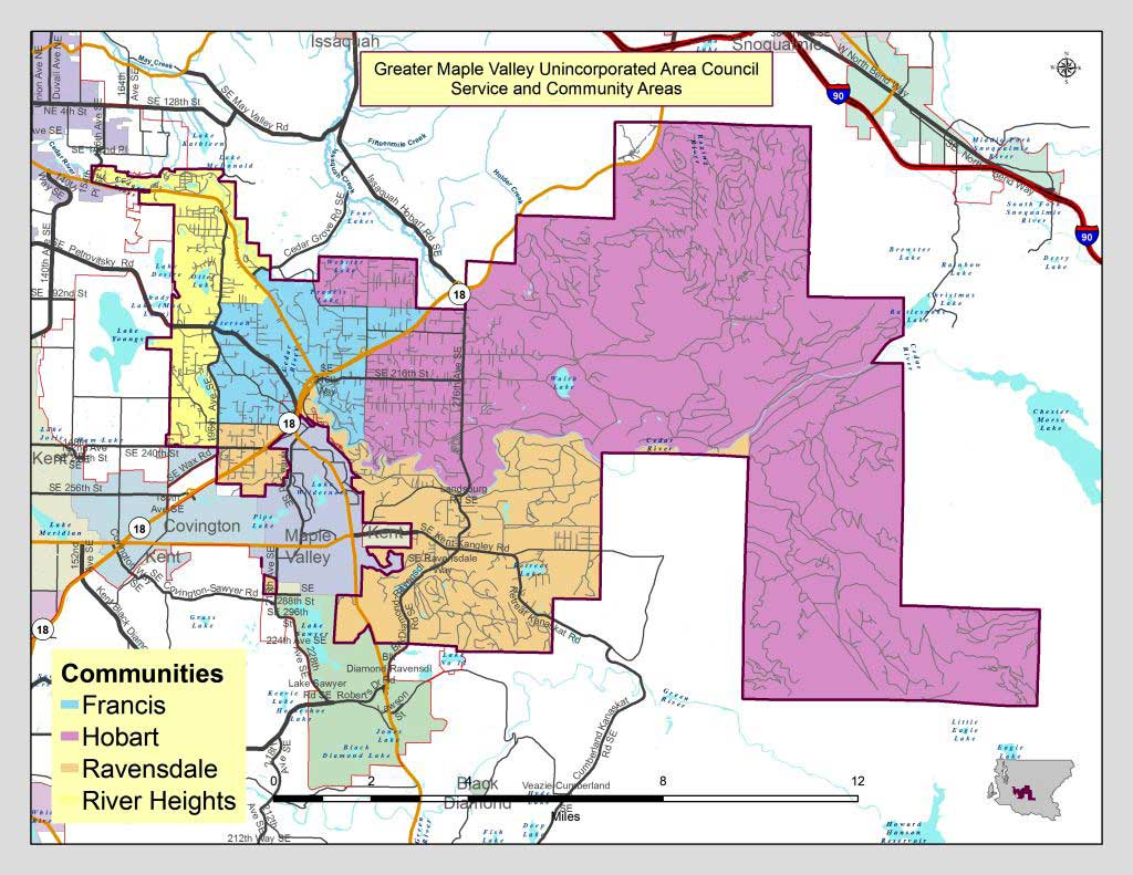
Greater Maple Valley
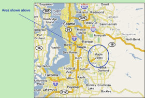
The GMVUAC serves the residents of unincorporated King County living in the Tahoma School District No. 409 (outside the city limits of Maple Valley). Our Washington nonprofit corporation was established in 1977; we serve a population of 16,100 (2010 Census); and our service area is 116 sq mi. Below is a map of our Service Area and the four Community Areas:
GMVUAC Monthly Meeting Articles
2025
* 5/5--JRT / KC Forum
* 4/7--Segale Mine
* 3/3--Reserve Silica
* 2/3--CAO Update
* 1/6--KCCP Update
2024
* 12/2--OSS Code Changes
* 11/4--Kickoff of Local Plan
* 10/7--Director of KC DLS
<8/5--No Article>
* 7/1--On-Site Septic Systems
* 6/3--Local Community Planning
* 5/6--Dept. of Local Services
* 4/1--Local Subarea Plan
* 3/4--Letter To KC Executive
* 2/5--Comments on KCCP Update
* 1/15--TSD 2024 Levies
For prior years see: Monthly Articles